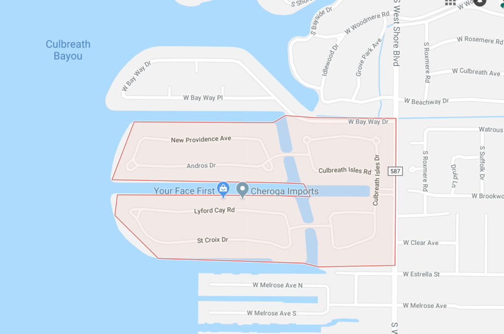
Culbreath Isles is a swanky and sought after waterfront neighborhood in Tampa. It’s boundaries are Beach Park to the north, Tampa Bay to the west and south, and Westshore Blvd. to the east.
Culbreath Isles is a neighborhood within the South Tampa district of Tampa. As of the 2010 census the neighborhood had a population of 574. The ZIP Codes serving the area are 33609 and 33629.
Some Culbreath Isles history from the Tampa Bay Times:
“Culbreath Isles is one of the most coveted addresses in Tampa, and its dredged canals and filled-in fingers are its dominating geographic feature, providing multi-million dollar views.
View Culbreath Isles Homes for Sale
Still, neither Culbreath Isles, platted in the early 1960s, nor Culbreath Bayou, platted a few years earlier, can claim to be the first Culbreath subdivision. That distinction belongs to Culbreath Beach, platted in 1892 — 22 years before the creation of Westshore Boulevard.
The Culbreath family first homesteaded the northwestern portion of the Interbay Peninsula in the late 1860s or early 1870s. Harry Culbreath came to Tampa following the Civil War, fleeing his war-torn home state of South Carolina. Culbreath cultivated oranges on his land — legend says he was the first orange grower to plant his trees in rows 25 feet apart — as did his closest neighbors.
Part of the Culbreath homestead included three mounds constructed by Native American Indians from 3,000 to 5,000 years ago. A distinctive lithic point, dubbed the Culbreath Point, was discovered and classified during the construction of Culbreath Isles in the early 1960s. The mounds were excavated and ultimately destroyed during the dredging of the east-west canal located at the entrance to the neighborhood.
By the 1890s, the shape of the Hillsborough River and Ybor City’s cigar industry began to steer Tampa’s growth to the north and east. Growth did jump the river at spots. Hyde Park became part of Tampa in 1887. West Tampa stood as an independent city from 1895 to 1925. Both of those, though, were fairly close to Tampa’s center.
Culbreath Beach was different. Organized in 1892 and nestled on a peninsula bounded on one side by Old Tampa Bay and two sides by a creek, it was among the earliest platted developments on Tampa’s western shore. It was likely situated near what was labeled, on an 1879 U.S. Coast and Geodetic Survey of Tampa Bay, “Cutberth’s Bayou,” a misprint of “Culbreath” that would survive on USCGS surveys into the 20th century.
Culbreath Beach offered lots large enough for both a home and a kitchen garden, or even a cash crop. People also traveled from Tampa for day trips and overnight stays at Culbreath Beach. Today, however, that waterfront is at least a quarter mile further to the west.
In 1913, Culbreath Beach’s proximity to the water drew the attention of “eastern capitalists” who considered constructing a ferry landing there. The idea was to carry passengers and freight to St. Petersburg, with streetcar connections on both sides of the bay. Neither the ferry nor the streetcars to the end of the Interbay Peninsula ever happened.
Instead, Culbreath Beach grew into the future as a residential development. In 1924, the Culbreath family put 14 acres, including 500 feet fronting on Old Tampa Bay, on the market for the “bargain” price of $60,000. Adjusted for inflation, that’s roughly $850,000 in today’s dollars — hardly enough for a 50-by-100-foot lot in the neighborhood.
The ad identified the property as “one of Tampa’s oldest landmarks, a real gem of nature, builded (sic) on the foundation of an Indian shell mound and studded with nature’s choicest shade-giving palms and oaks.” Nearby, the listing said, was the new Beach Park neighborhood, then under construction.
The real estate crash hit before Culbreath Beach could be fully developed. The post-World War II land boom completed what the 1920s boom started, and South Tampa — particularly its areas near the water — quickly filled up with homes.
During the 1950s and 1960s, the shoreline was added onto and canals were created to add to the number of available waterfront lots. Culbreath Bayou, the geographic location, and Culbreath Beach, the recreational and farming area, became full-fledged neighborhoods, but they still carried the Culbreath name.”